

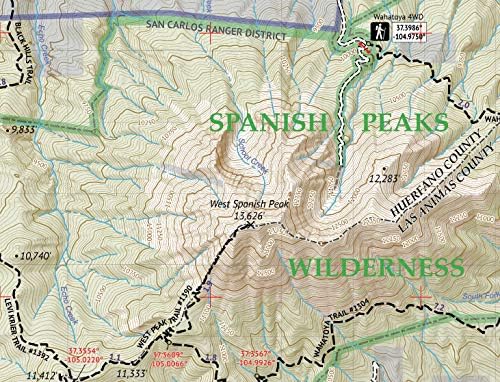
Outdoor Trail Maps Greenhorn Mountain/Spanish Peaks Wilderness – Colorado Topographic Hiking Map (2019)
$8.95


Price: $8.95
(as of Mar 21,2022 16:10:23 UTC – Details)

Waterproof, tear-resistant topographic hiking map covering all of the hiking trails in the Greenhorn Mountain Wilderness and Spanish Peaks Wilderness areas of Colorado, including the Wet Mountains and the San Isabel National Forest trails near La Veta and Cuchara. The front side of the map covers the Spanish Peaks and surroundings, including the East and West Spanish Peak Trail, Wahatoya Trail, etc just south of Walsenburg, CO. The back of the map shows the middle and southern portions of Wet Mountains, including the Greenhorn Mountain Wilderness, as well as numerous motorized and hiking trails north of Greenhorn Mountain.
Waterproof, tear-resistant, 1:52,000 scale with a compact 4″x7″ folded size for your pocket
Smaller and lighter – no more unfurling huge maps – designed for on-trail use
Segment distances – mileage – for all trails
Up-to-date for 2019 with accurate trail routings and distances
GPS coordinates for trailheads and trail junctions – device compatible
Related Products


$8.95